 Version
5.2.5
Version
5.2.5
 Package Name
com.mlanger.slovenskomtb
Package Name
com.mlanger.slovenskomtb
 Category
Sports and Health
Category
Sports and Health
 Size
22.05MB
Size
22.05MB

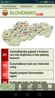
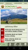
MTB Cycling Tracks for A Total of Mountain Biking Enthusiasts.
MTB cycling routes for all mountain biking enthusiasts who like to cycle in the Slovak mountains. It contains dozens of routes in different mountains. Especially the regions of Donovaly and Horehronie are processed.
Website: http://cyklowebka.sk
Rastry DESCRIPTION + GPS
The description of each route contains text, photos, GPS trackpoints and so -called. Points of interest (refreshments ...). GPS Trackpoints and points of interest are displayed on the map, respectively. They can be exported and used in another application or other GPS devices.
Maps
After installing the application, it is good to download your own offline map with the Download function, giving the Internet utility. In addition, there are several other maps online. It is also possible to use your own offline map. All maps can be zoomed more than native zoom.
The following maps to choose from:
- Various topographic maps SK with tourist brands and forest roads NLC
- worldwide popular Google and OSM maps
- Your own offline maps in SQLITEDB format
Navigation
The following features can be used for navigation:
- View the route
- View your own position
- Compass view
Tracking
This feature records the route passed. In addition to GPS coordinates, the record also includes information about time and altitude. It is possible to add your own points on the route (so -called Waypoints), which may also include photos from the gallery.
Cyclocomputer
The following features can be used in Tracking mode:
- Record of the route
- Showing an altitude
- View the distance traveled
- Showing the height meters of
Objects
The application downloads different types of objects that are interesting for the cyclist (accommodation and restaurant facilities, water springs, cultural and historical buildings ...). Depending on the option, objects appear in the map.


 Download APK(22.05MB)